
Catonsville Rails to Trails Trail Tour
Get familiar with our trails; the route, the sights, the history, and the art! Watch the video, view the trail map, and find more information below!
Legend

Click the point of interest on the map to learn more.
#8 Streetcar Path
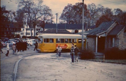
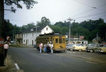
The historic #8 Streetcar Path is a 1/3-mile paved trail in west Catonsville, starting near Matthew’s 1600 Restaurant on Frederick Road and ending at the Catonsville Junction Business District near Scittino’s Restaurant on Edmondson Ave.
Mostly flat with a slight incline at the Edmondson end, it’s ideal for seniors thanks to its short length, easy terrain, and nearby restaurants. The trail features two benches, is ADA accessible, and offers parking behind the 7-Eleven at 1611 Edmondson Ave.
Short Line Trail
The Catonsville Short Line Trail is a 2.2-mile woodland path that begins near the Catonsville Fire House and wind through a dozen neighborhoods, Spring Grove State Hospital Center, and Paradise before ending near Charlestown Senior Living Community. An extension beyond Charlestown is planned.
The trail is flat with an unpaved crusher-run surface. Some sections are on-road, including a beltway bridge crossing.
Parking is available along Garden Ridge Road, Paradise Ave, and Shady Nook Ave.
#9 Trolley Trail
The historic Ellicott City/Catonsville Trolley Line #9 Trail is a 1.25-mile boardwalk and paved trail that begins at the west end of Edmonson Avenue (at Chalfonte Ave.) and extends from Catonsville through Oella to Main Street, Ellicott City, and the Patapsco State Park. This trail has a steady incline. This trail is maintained by Baltimore County.
 #8 Streetcar Path – Trailhead Mural
 #8 Streetcar Path – Trailhead Mural
The mural at Catonsville Junction features Ed Griffin, a generous donor and owner of Catonsville Automotive, as the streetcar driver, and includes a 7-Eleven logo added by CRTT to honor the property owner. It also portrays Dr. Bob Irwin and his wife Marjean, a muralist, in a window, and Maureen Sweeney Smith, co-founder of Catonsville Rails To Trails, with her dog Skeeter on a porch facing the trail.
inline or in the module Content settings. You can also style every aspect of this content in the module Design settings and even apply custom CSS to this text in the module Advanced settings.

Streetcar Waiting Shelter
 Streetcar Waiting Shelter
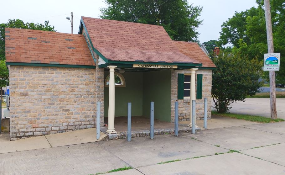 This unique structure, built in 1939 by the Baltimore Transit Company to serve waiting passengers at the terminus of the #8 Towson-Catonsville streetcar line, was constructed using Belgian paving blocks reclaimed from the streets of nearby Baltimore, Maryland. In addition to waiting space, it also incorporated a streetcar operator’s restroom and a sand storage bin. After streetcar service ended in 1963, BTC was served by Maryland Mass Transportation Administration buses until 1997, when the shelter was restored to its original appearance by local historian, Dave Ditman, through the efforts of the Old Catonsville Neighborhood Association. This Baltimore County Landmarked Structure is maintained by Catonsville Rails to Trails volunteers and the MTA.
Berley Roberts Mural
 Berley Roberts Mural
The Berley Roberts, Sr. Streetcar Mural, located on the #8 Streetcar Path in Catonsville, was originally created in 1997 by 14-year-old Eagle Scout Clark LeCompte as a tribute to the historic Catonsville Junction. The 1,440 sq. ft. mural features a full-sized streetcar and depicts scenes from the mid-20th century, including local landmarks and community life. In 2021, Catonsville Rails to Trails refurbished the mural and added Berley Roberts, Sr.—the first Black streetcar operator on the #8 route—as the driver, honoring his pioneering role in Baltimore’s transit history. The mural also includes whimsical and historical details like the Pig Path, the Caton Tavern, and childhood memories from local residents. Roberts’ family visited the mural in 2023, deepening its legacy as a celebration of resilience, inclusion, and community storytelling.

Railroad Crossbuck Sign
 Railroad Crossbuck Sign
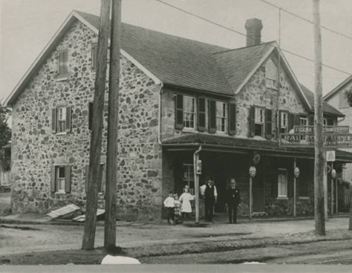
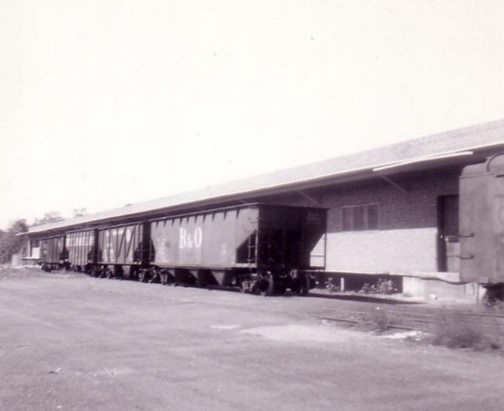
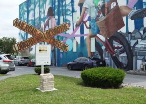 From 1884 to 1972, the Catonsville Short Line Railroad served the residents of Catonsville providing passenger and freight services to Baltimore. A small depot and ticket office were erected on this site. In 1897, the new electrified streetcar line had the effect of drawing away most of the Short Line’s passenger traffic causing the railroad to discontinue passenger service in 1898. Freight service continued providing Catonsville with coal for heating and building supplies . By the 1970s, goods were being transported by trucks and local institutions had stopped using coal with Spring Grove Hospital receiving the last load in December 1970.
The Catonsville Historical Society (CHS) agreed to preserve a cast iron railroad crossbuck sign in 1980 and it was moved from the Short Line Railroad to their property at 1824 Frederick Road. When the CHS sold the Townsend House and museum in 2021, they donated the sign to CRTT and paid to have it moved to Railroad Park located at 745 Frederick Road.
Warehouses
 Warehouses
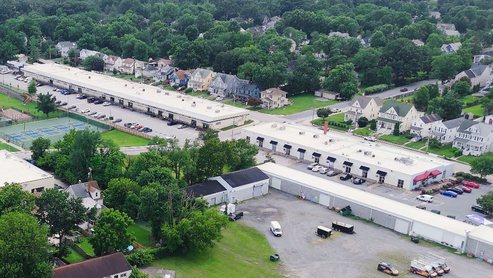
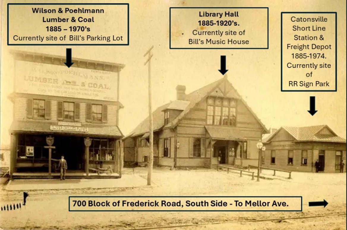
The buildings at The Shops on Mellor were originally the warehouses for the freight that was delivered by the Catonsville Short Line train. That is why these buildings have an elevated walkway porch along the front of the building. The train had a spur that headed to Wilson Lumberyard to deliver building supplies and coal. Freezers were installed in these warehouses in the 50s-60s and for the first time providing Catonsville supermarkets with TV dinners, frozen vegetables and ice cream.
Catonsville Schools
 Catonsville Schools
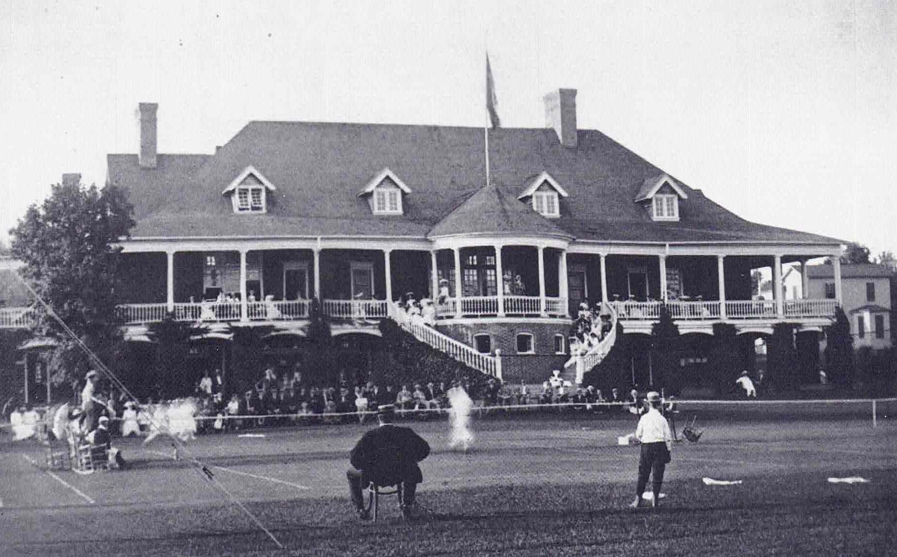
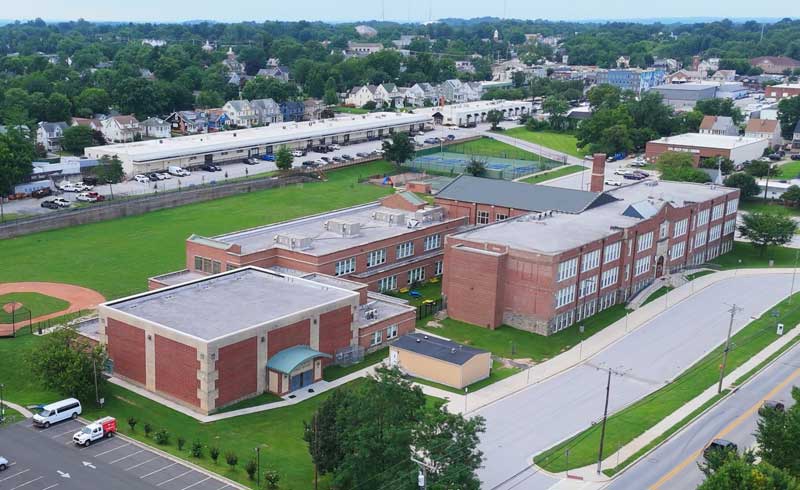
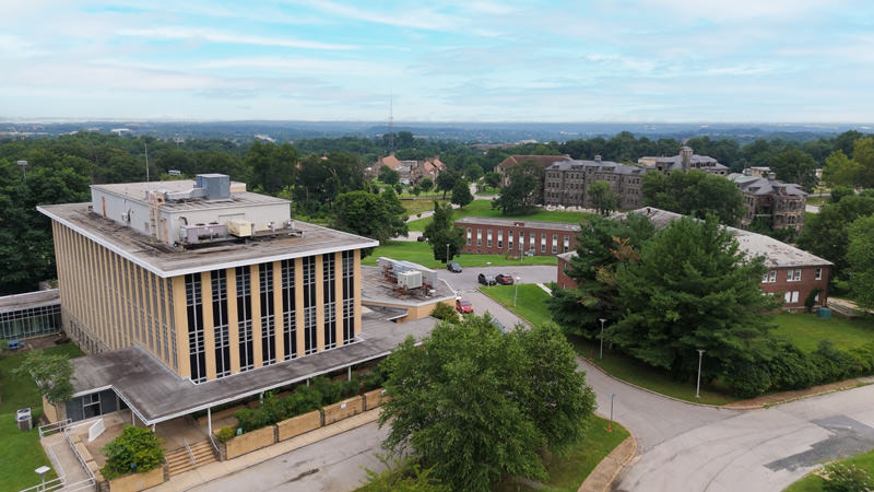
In 1925, Baltimore County purchased the land and demolished the Catonsville Country Club building for a new high school which opened in the fall of 1926. In 1954, a new high school was built at the corner of Bloomsbury and Rolling Road and the school became the Catonsville Junior High (grades 7,8,9) and later the Catonsville Middle School (grades 6,7,8).
The school board wanted to demolish the building in 1995, but protests from residents resulted in the building becoming a community center. In 2016, the school became the new elementary school after a $28 million renovation project that included a $36,000-square foot addition and air conditioning.
Spring Grove Hospital & Coal Delivery
 Spring Grove Hospital & Coal Delivery
Founded in 1797, Spring Grove State Hospital, now known as Spring Grove Hospital Center, is the second oldest continuously operating state psychiatric hospital in the country. In late 1852, this 136-acre parcel was selected as the site for the new hospital and was known as Spring Grove because it contained a number of spring-fed ponds and streams. The new hospital served 325 patients and opened on October 7, 1872.
The Catonsville Short Line Railroad hauled large quantities of coal that was delivered to St. Charles College (now Charlestown) and Spring Grove State Hospital. The Spring Grove Power Plant provided steam heating though out Spring Grove’s facility until 1972.
Mural at Shady Nook
 Mural at Shady Nook
When the State Highway Administration widened the Beltway in 1982, they removed the Catonsville Short Line (CSL) Railroad Bridge, a connector between the east and west sides of Catonsville near Spring Grove Hospital that was built in the 1960s. The CSL had been abandoned 10 years earlier after 88 years of service.
CRTT Board Member Sheldon Smith wanted trail users to understand and remember the Short Line route, including the bridge. Sheldon called on local realtor Wes Peters and artist Edward Williams to fund and paint the Shady Nook trail mural. The mural was completed in Spring, 2014.
Residents enjoy taking selfies at this mural including a reenactment of the popular 1960s cartoon Dudley Do-Right of the Mounties, a segment on The Rocky and Bullwinkle Show. Do-Right is always trying to catch his nemesis, Snidely Whiplash, and rescue Inspector Fenwick’s daughter, Nell Fenwick, when she is tied to the railroad tracks.

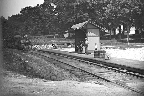
Paradise Train Station
 Paradise Train Station
The Catonsville Short Line Railroad was dotted with seven small train stations. This train station, at the corner of Paradise and Prospect Aveneus, was photographed by Dr. G. Howard White who lived on Prospect Ave.
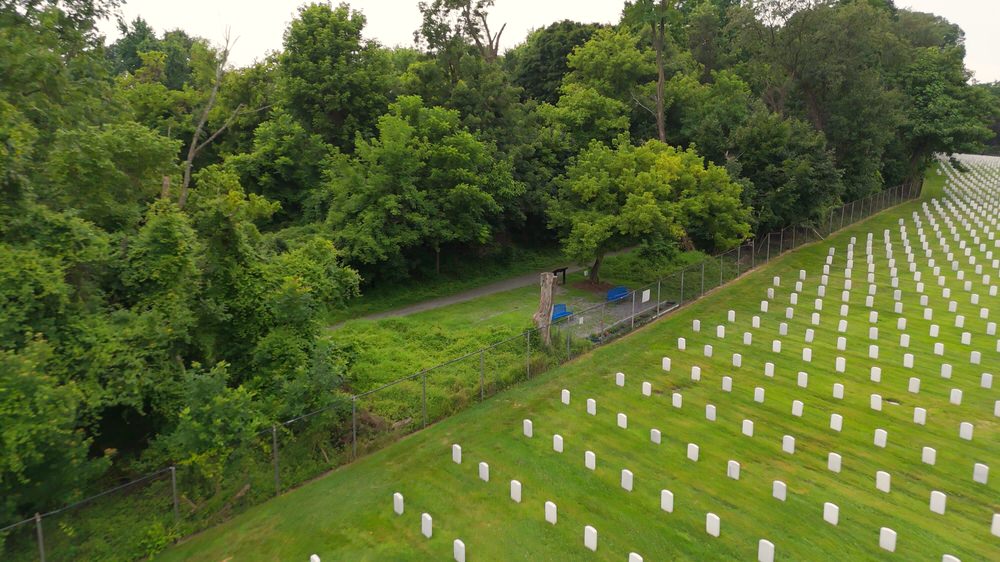
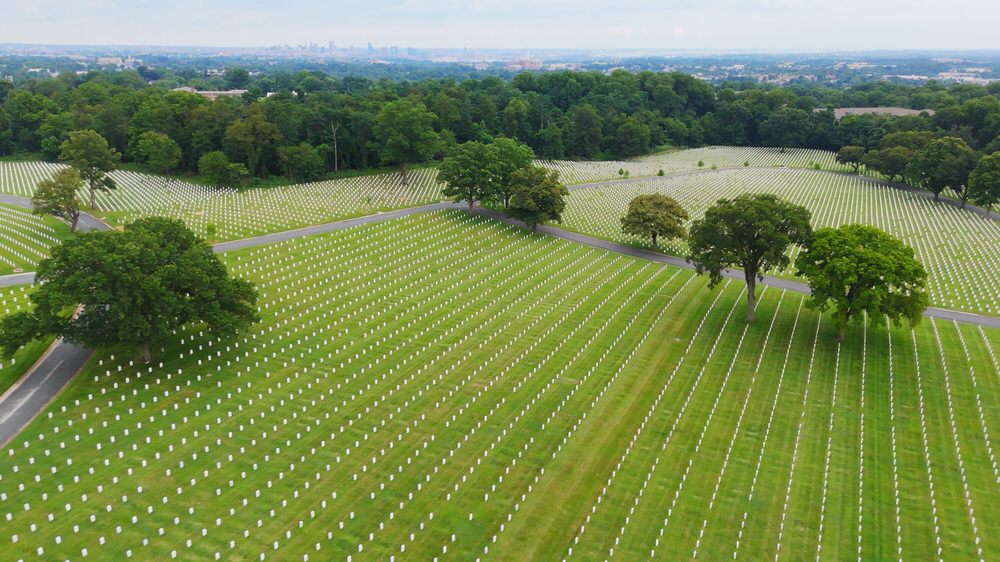
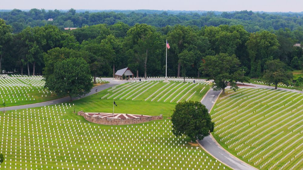
Cemetery Overlook – Little Arlington
 Cemetery Overlook – Little Arlington
The Baltimore National Cemetery was one of seven national cemeteries created between the World Wars, 1934–1939. It was the Army’s first major expansion since the Civil War, directed at serving a growing veteran population and the rapidly depleting burial space at existing national cemeteries.
The cemetery’s site was an historic estate called Cloud Capped (or Cap), which occupied an elevated setting adjacent to Frederick Road as early as 1750. The property was part of the Baltimore Company (Iron Ore) holdings and Charles Carroll of Carrollton, a signer of the Declaration of Independence, was an investor.
In 1890, when socially prominent Blanchard and Susan Randall acquired the estate as a summer home, its 90 acres extended from Frederick Rd. to Wilkens Ave. A railroad stop near the property made it easily accessible to downtown Baltimore in the late 1800s.
Nearby, the diminutive 5.2-acre Loudon Park National Cemetery was at or approaching capacity, and additional burial space was needed. The Randalls sold their property for $95,000 to the government, which took possession in 1936. The Cloud Capped estate was converted to a national shrine under the Works Progress Administration (WPA), a Depression-era make-work program that employed 100-150 men between 1937 and 1940.
The first interment was on December 18, 1936, although the cemetery was formally dedicated on Memorial Day, May 30, 1941. There are approximately 47,000 internments at this location.
Additional Resources
Public Art Virtual Tour

Explore the murals and public art on and near the trails. Take a look virtually in 3D and learn details about the art, artists, and historical depictions.
Public Art Walking Tour

Walk the trails and through downtown Catonsville to see the murals and public art with guided directions. Learn details about the art, artists, and historical depictions.
Other Resources


Credit
Dan Adler – Owner/Operator Catapult Image Virtual Spaces. Video production, drone piloting, video editing, and web page construction. All visual and audio content for this project was captured and produced by Dan Adler and Catapult Image, save for historic photography provided by CRTT. Thanks to Eric Von for additional video capture and production assistance.
Thanks to our bike riders featured in the video: Erin Walton, Charlie Murphy, and Evan Wasser.