
Help Us Fill the Map
We need your help to fill in the PSAP map. Follow the guide below to leave comments and please let MDOT know that only a fully grade separated shared-use path on both sides of US 40 will keep bicyclists and pedestrians safe. In this context a shared-use path is a 10-12′ wide paved path with a 4′ buffer adjacent to the roadway. The full list of countermeasures to suggest can be found here.
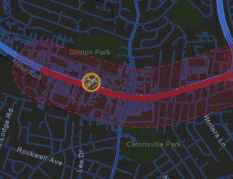
The Maryland Department of Transportation (MDOT) State Highway Administration (SHA) has released a project page for a US 40 Pedestrian Saftey Action Plan (PSAP). The project corridor spans US 40 from Charring Cross Rd to Nuwood Dr.
To make travel safer for all road users, this project will make context driven improvements along 2.85 miles from Charring Cross Road to Nuwood Drive in Baltimore County.
The project was announced January 26, 2026, and the PSAP process is currently in the DESIGN phase.
MDOT SHA is collecting comments for the corridor using an ArcGIS tool which is available on the project page or accessed directly here: PSAP Project – Public Feedback. The ArcGIS tool will display all of the PSAP projects, the user needs to search for US 40 or pan and zoom to US 40 in Catonsville.
PSAP projects focus on the most dangerous roads throughout the State. We need your help to ensure the project moves forward with the best information from as many potential users as possible throughout our community.
WMAR 2 News Story: Catonsville’s Rt. 40 among state highways slated for safety improvements.
How to Use US 40 PSAP ArcGIS
Follow this link to the dedicated ArcGIS page: PSAP Project – Public Feedback.
Agree to Terms & Conditions
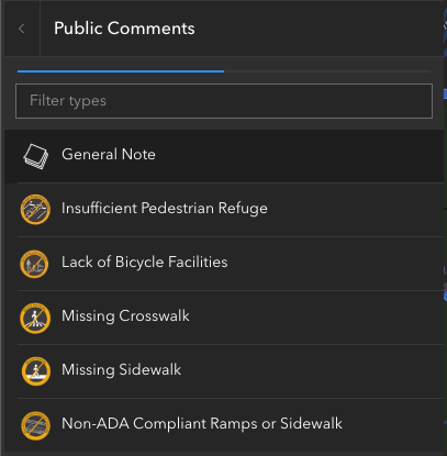
The ‘MDOT Terms & Conditions’ give the instructions for how to find the ‘US 40’ project and what feedback they are looking for.
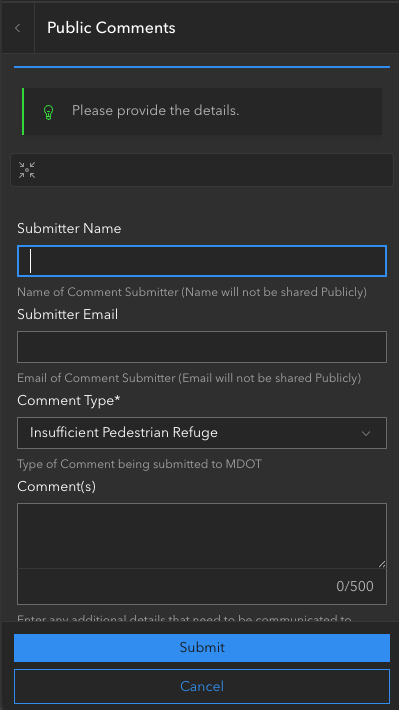
- Insufficient Pedestrian Refuge
- Missing Crosswalks
- Missing Sidewalks
- Lack of Bicycle Facilities
- Non-ADA Compliant Ramps of Sidewalks
- General Notes
Click the “I agree…” check box and then the ‘OK’ button to enter the tool.

Pan to US 40
The ArcGIS tool will open centered on Laurel, MD. You will need to use the ‘Search by Route’ box or you can pan and zoom to US 40 to find the project corridor. To use the ‘Search by Route’ box enter ‘US 40’ and press enter or select an option from the dropdown. The corridor is technically split into two sections; only one project section will be highlighted at a time.

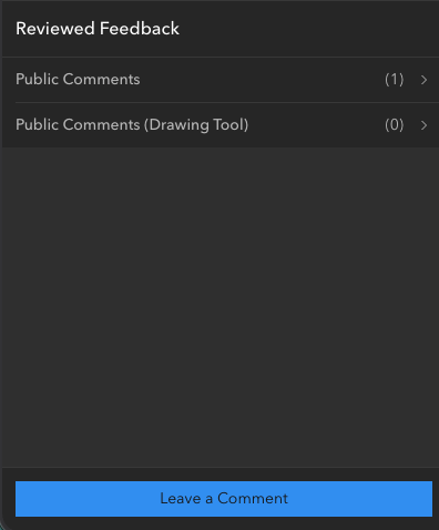
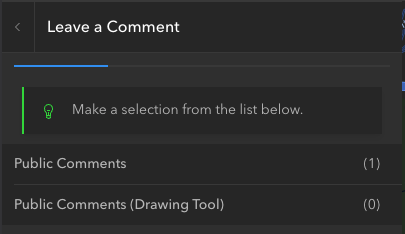
Submit Comments
Using the left hand side bar, submit your comments and issues for the PSAP project. Below is a step-by-step guide to submitting a comment.
We encourage you to submit a ‘General Note’ indicating the need for a grade separated side-path on both the east-bound and west-bound sides of US 40.
How to Submit a Comment
Important Crossroads
Below are several important crossroads that need to be addressed in this project and infrastructure design elements that we recommend. Please leave a comment at these crossroads identifying the current issues and the types of improvements you’d like to see.
Crossroads:
- Nuwood Drive
- N Rolling Road
- Winters Lane
- Ingleside Ave
- Johnnycake Road
- St. Agnes Lane
- Coleridge Road
- Charing Cross Road
Infrastructure Design Elements:
- Lane Width Reduction
- Leading Pedestrian Intervals
- No Turn on Red
- Protected Intersections
- Speed Limit Reductions
- Exclusive Pedestrian Phase
- Reduced Curb Radii
- Curb extensions
- Roadway Reconfiguration
- Raised Crosswalk
- Removal of Channelized Turn Lanes
A full list of the infrastructure design elements (Context Driven Toolkit) can be found here.
Recent Comments